• Severe Thunderstorm Warning for Calhoun - Click for Details
    ... Northwestern Cherokee County in north central Georgia...
    ... Southwestern Pickens County in north central Georgia...
    ...hail or flooding...
    ...RADAR INDICATED MAX HAIL SIZE...
    ...RADAR INDICATED MAX WIND GUST...
    Expires: June 14, 2025 @ 5:45pm
    SEVERE THUNDERSTORM WARNING FOR
    Northwestern Cherokee County in north central Georgia... Southeastern Gordon County in northwestern Georgia... Southwestern Pickens County in north central Georgia... Northeastern Bartow County in northwestern Georgia... * Until 545 PM EDT. * At 457 PM EDT, a severe thunderstorm was located over Adairsville, or 8 miles south of Calhoun, moving east at 40 mph.
    HAZARD
    60 mph wind gusts and dime size hail.
    SOURCE
    Radar indicated.
    IMPACT
    Expect damage to roofs, siding, and trees.
    LOCATIONS IMPACTED INCLUDE
    Cartersville, Calhoun, White, Fairmount, Ranger, Sonoraville, Salacoa Valley, Pine Log, Redbud, Folsom, and Funkhouser.
    PRECAUTIONARY/PREPAREDNESS ACTIONS
    For your protection move to an interior room on the lowest floor of a building. If you see wind damage...hail or flooding...wait until the storm has passed...and then call the National Weather Service toll free at 1 8 6 6 7 6 3 4 4 6 6 or tweet us your report at NWSATLANTA. HAIL THREAT...RADAR INDICATED MAX HAIL SIZE...0.75 IN WIND THREAT...RADAR INDICATED MAX WIND GUST...60 MPH
  • Severe Thunderstorm Warning for Calhoun - Click for Details
    ... East central Floyd County in northwestern Georgia...
    ... Northwestern Bartow County in northwestern Georgia...
    ...hail or flooding...
    ...RADAR INDICATED MAX HAIL SIZE...
    ...RADAR INDICATED MAX WIND GUST...
    Expires: June 14, 2025 @ 5:15pm
    SEVERE THUNDERSTORM WARNING FOR
    East central Floyd County in northwestern Georgia... Southwestern Gordon County in northwestern Georgia... Northwestern Bartow County in northwestern Georgia... * Until 515 PM EDT. * At 433 PM EDT, a severe thunderstorm was located over Armuchee, or near Rome, moving east at 30 mph.
    HAZARD
    60 mph wind gusts and dime size hail.
    SOURCE
    Radar indicated.
    IMPACT
    Expect damage to roofs, siding, and trees.
    LOCATIONS IMPACTED INCLUDE
    Adairsville, Kingston, Plainville, Cassville, Shannon, and Pinson.
    PRECAUTIONARY/PREPAREDNESS ACTIONS
    For your protection move to an interior room on the lowest floor of a building. If you see wind damage...hail or flooding...wait until the storm has passed...and then call the National Weather Service toll free at 1 8 6 6 7 6 3 4 4 6 6 or tweet us your report at NWSATLANTA. HAIL THREAT...RADAR INDICATED MAX HAIL SIZE...0.75 IN WIND THREAT...RADAR INDICATED MAX WIND GUST...60 MPH

Sheriff’s Office Dismantles Meth Conversion Lab in Calhoun

SHARE NOW

Calhoun, GA – June 12 — A major methamphetamine conversion operation was shut down Thursday afternoon following an investigation by the Sheriff’s Drug Enforcement Unit.

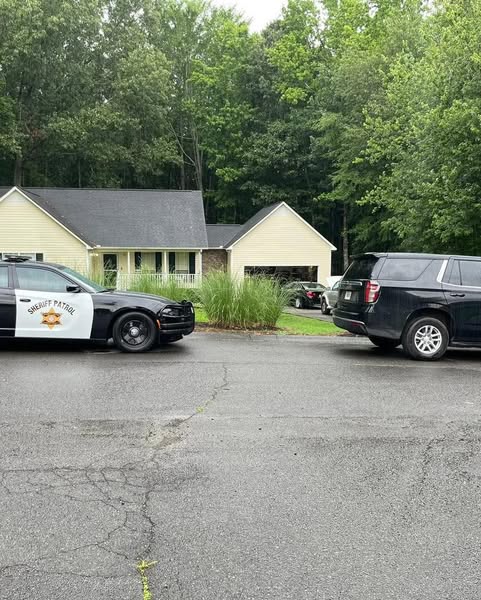
Detectives began looking into reports of meth trafficking in May, focusing on a residence located at 200 Tara Drive near Calhoun. With support from Probation and Parole officers from the Department of Community Supervision, a search was conducted at the home as part of the ongoing investigation.

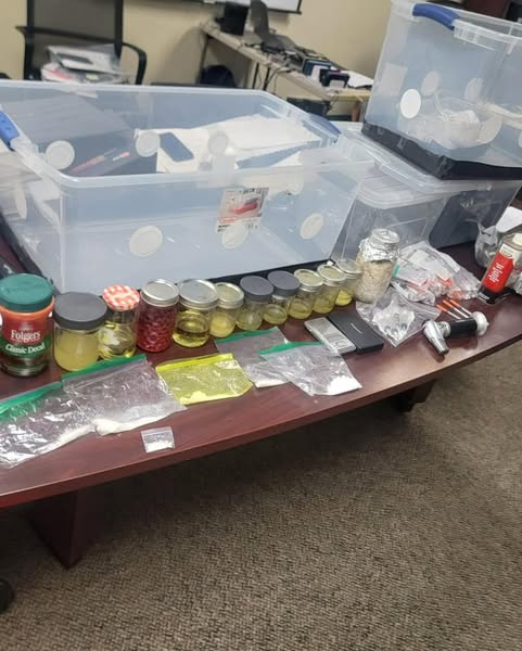
Inside the residence, investigators discovered a substantial quantity of both crystal methamphetamine and liquid methamphetamine, along with equipment used to convert liquid meth into its solid, traffickable form. Additional illicit substances—including cocaine and psilocybin mushrooms—were also found.

The home’s occupant, 62-year-old Tracy Van McEntyre, was arrested at the scene. He faces multiple charges, including Manufacturing and Trafficking Methamphetamine, as well as other drug-related offenses. According to jail records, McEntyre has been arrested more than ten times and has at least two prior convictions for drug trafficking.

Authorities have not released further details as the investigation remains active.